Map of India Solutions for ICSE Class 10 Geography Ch- 2 Exercise Questions .The Solutions of All type exercise Questions ie Very Short ,Short, Long Questions , Give reason , Differentiate, Map Plotting and Name of following for cracking the next upcoming Sem-2 exam of council. Visit official website CISCE for detail information about ICSE Board Class-10 Geography
Chapter-2 Map of India Solutions for ICSE Class 10 Geography
| Board | ICSE |
| Class | 10th (X) |
| Subject | Geography |
| Chapter | Map of India |
| Syllabus | on bifurcated syllabus (after reduction) |
| Session | 2021-22 |
| Bifurcated | Sem-2 |
| Topic | Descriptive / Subjective Question for sec-B |
Map of India : Very Short Questions
Solutions for ICSE Class 10 Geography Chapter-2
Question 1: By what name is the parallel of latitude 23° 33′ known? Name the zones or belts into which it divides India almost equally.
Answer: Tropic of Cancer; Tropical and Temperate Zones.
Question 2: Name the source of the river Ganga. Where does this river enter the plains?
Answer: The source of the river Ganga is ‘Gangotri glacier’ of the great Himalayas. The river enters the plain from North-Western part of Uttar Pradesh and Uttaranchal above that is Shivalik hills.
Question 3: Explain why the Damodar is called the “Sorrow of Bengal”?
Answer: The Damodar is known as the “Sorrow of Bengal” because it floods frequently and causes wide spread destruction of lives, cattle and crops.
Question 4: Why is the Pamir Knot known as ‘the roof of the world’.
Answer: Pamir Knot is known as ‘the roof of the world’, because of its vastness and great height.
Question 5: Name the mountain ranges that lie along east and west of Pamir Knot.
Answer: The Himalayas in India, Nepal and China, Arakan Yoma range in Myanmar and the Kara Koram range and Hindukush range.
Question 6: Name the world’s first and second highest mountain peaks.
Answer: First highest Mount Everest, second highest Peak Mt. K2.
Question 7: Where is Zojila Pass?
Answer: It is in the state of Jammu and Kashmir.
Question 8: From where does the river Ganga, Indus and Brahmaputra get their water?
Answer: The river Ganga, Indus and Brahmaputra get their water from the Himalayas.
Question 9: Where are the Sunderbans?
Answer: The Seaward face of the delta of Ganga has sand banks and inlands known as the Sunderbans.
Question 10: Name the two component parts of the Indo-Gangetic Plain?
Answer: The spurs of the Aravalli range act as watershed between the two component parts of the Indo-Gangetic plain. They are the Indus-Basin and the Ganga-Basin.
Question 11: The northern plains of India are one of the most densely populated regions of the world. Why?
Answer: They are the most densely populated regions because they are very level and flat and made up of fertile alluvial soil.
Question 12: Mention the sub-units into which the Deccan Plateau region can be divided.
Answer: The Plateau region can be divided into the following sub-units, the Malwa Plateau, the Chhota – Nagpur Platea
Question 13: Mention the sub-units of the Deccan Plateau?
Answer: The Deccan Plateau has been divided into the following sub-units: Maharashtra Plateau, Andhra Plateau and Karnataka Plateau.
Question 14: Which is known as the Deccan Trap region?
Answer: The north-western part of the Deccan Plateau in Maharashtra, adjoining Madhya Pradesh and Gujarat is known as the Deccan Trap region.
Question 15: Which mountains divide the Northern India and Peninsular India?
Answer: The Satpura mountains.
Question 16: Which is the highest peak of the Peninsular India?
Answer: The Anaimudi in the Anamalai hills is the highest peak in the peninsular India being 2,695 metre, high.
Question 17: Where does the Karnataka Plateau end?
Answer: Karnataka Plateau ends at the meeting place of the Western Ghats and Eastern Ghats.
Question 18: What is the other name of the east coastal plain?
Answer: Coromandel Coast.
Question 19: Which is the most important lake on the eastern coastal strip?
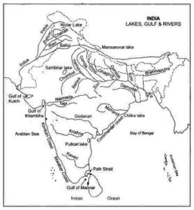
Answer: Lake Chilka in Orissa.
Question 20: “Access through Western Ghats is difficult.” Why?
Answer: They form a continuous chain running from north to south, access through which is very difficult.
Question 21: Why is the Thar Desert most sparsely populated part of India?
Answer: The absence of water for irrigation and level land which could be irrigated have made this region the most thinly populated part of India.
Question 22: Where is the Rann of Kutch located?
Answer: The Rann of Kutch is located in the Kathiawar section.
Map of India : Short Questions
Solutions for ICSE Class 10 Geography Chapter-2
Question 1: Why is South Asia referred as Indian Sub-continent?
Answer: A sub-continent is a big geographical unit which stands out distinctly from the rest of the continent. Politically the continent is divided into many countries (SAARC countries). India forms the main part of the sub-continent so South Asia is often referred as Indian sub-continent.
Question 2: How is Indo-Gangetic plain formed?
Answer: The Indo-Gangetic plain is formed by the Indus, Ganga and their tributaries. River Indus (2,736 km) rising from across the Himalayas winds through Pakistan and drains into the Arabian Sea. The Ganga (2,510 km) and their numerous tributaries which flow across northern India and Bangladesh drain into the Bay of Bengal.
Question 3: Write down the importance of Indo-Gangetic plain.
Answer: Indo-Gangetic plain is one of the most important agricultural region of the world, producing a wide variety of crops. It is a granary of the world, producing rice and wheat in large quantities and it is the most thickly populated part of India.
Question 4: How are rivers of Northern India important?
Answer: (i) They yield constant supply of water.
(ii) They bring fertile alluvium soil suitable for agriculture.
(iii) They provide good highways of communication though they are much less used than formerly.
Question 5: Describe the Deccan Plateau region.
Answer: The Decean Plateau is highly dissected and is broken by hills and river valleys. It is composed of old, hard, crystalline rocks. It is bounded on the north by the ranges of Vindhyas and the Satpura, on the west by the Western Ghats and on the east by the Eastern Ghats.
Question 6: (i) Where does the Malwa Plateau lie?
Answer: (ii) How is it formed?
(i) The Malwa Plateau lies in the north-west part of the Plateau region.
(ii) This upland region is formed by sand stone, shells and limestone. It is drained by a number of north-flowing streams, like Chambal, Betwa and their tributaries.
Question 7: How has the lava-flow rocks of Deccan Plateau changed into fertile black soils?
Answer: The Deccan Plateau region is built up by the lava-flow rocks, which have been changed into fertile black soils because of continuous weathering through ages. The region of black soil is very suitable for cultivation of cotton plants.
Question 8: What is the importance of the Southern Plateau Region?
Answer: It is geologically very old and stable land and therefore least affected by the tectonic disturbances or by tremors of the earth. It is a storehouse of many mineral deposits like coal, iron-ore, manganese ore, mica, bauxite and many other minerals are found in this Plateau region.
Question 9: What is the extent of eastern coastal strip?
Answer: The east coastal strip extends from the mouth of the river Ganga to Cape Comorin. It lies between the Eastern Ghats and the Bay of Bengal.
Question 10: What is the extent of western coastal strip?
Answer: The west coast strip extends from Gulf of Kutch in the north to Cape Comorin (Kanyakumari) in the South. It lies between the Western Ghats and the Arabian Sea.
Question 11: What is the importance of coastal plains?
Answer: Both eastern and western coastal plains are favourable regions for agricultural purposes. They enjoy equable temperature condition throughout the year and as such they are suitable regions for human habitation. These plains have great facilities of good ports and harbours, also contribute greatly to the development of trade and commerce both internal and external in India.
Question 12: What are the salient characteristics of Shivaliks?
Answer: The Shivaliks, the southernmost range of the Himalayas, are also known as the outer Himalayas. This range is made of unconsolidated river deposits. It is more prominent in its western parts than the eastern parts of the Himalayas. This range is prone to landslides and earthquakes. The problem of soil erosion is worst here due to indiscriminate felling of trees.
Question 13: What do you understand by ‘Purvanchal’?
Answer: Purvanchal is a name of the mountains located on the North-eastern part of India. These mountains consist of Patkoi Bam and Naga hills in the North, Garo, Khasi and Jaintia lie in the centre and the Mizo and Lushai hills are in the south.
Question 14: (i) Define Coral Islands and Volcanic Islands.
(ii) Define Lagoons.
Answer: (i) Coral Islands: When Coral polyps die, their skeletons turn into large masses of white calcium carbonate, giving rise to white sands. Lakshadweep is coral island.
Volcanic Islands: Many of the islands of the Andaman and Nicobar are volcanic in nature.
(ii) Lagoons are salt water lakes which are almost separated from the Sea by the formation of sandbars along the coast.
Map of India : Long Questions
Solutions for ICSE Class 10 Geography Chapter-2
Question 1: Name the rivers, falling in Arabian Sea and Bay of Bengal.
Answer: Rivers falling into the Arabian Sea: The Narmada and the Tapti rise near the eastern extremity of the Satpura hills, flow westward and fall into the Gulf of Cambay. These rivers do not form any deltas because the tides wash away all the alluvium that the rivers bring. During flood, these rivers are navigable. Their chief use is that railways have been built in their valleys.
Rivers falling into the Bay of Bengal: The Mahanadi rises in the hills of Madhya Pradesh, while the Godavari, the Krishna and the Cauvery rise in the Western Ghats and flowing eastward fall into the Bay of Bengal. All these rivers are broken by rapids and hence are not useful for navigation. The deltas of these rivers are very fertile and are irrigated by the canals taken from these rivers.
Question 2: (i) State the type of rocks found in the Plateau of Peninsular India?
(ii) Name the three important lakes of Peninsular India?
(iii) How was the Great Indian Plateau formed?
Answer: (i) Old igneous rocks and metamorphic rocks.
(ii) The three important lakes are Chilka Lake in Orissa, Kochru Lake in Andhra Pradesh and Pulicat Lake in north of Chennai.
(iii) The Great Indian Plateau is the broken part of the old land mass called Gondwanaland. It was formed at the time of the splitting and moving the land mass.
Question 3: (i) Give a brief note on Islands of India.
(ii) Where does the Lakshadweep group of islands lie?
Answer: (i) The Indian islands in the Bay of Bengal consist of the Andaman and the Nicobar groups. Some of which are of volcanic origin. There are about 200 Islands in the Andaman groups alone, extending for 350 kilometres and 19 islands in the Nicobar group. Some of the Islands extend from 60 to 100 km., forming a cluster south of the Andaman group.
The Arabian Sea Islands consist of the Lakshadweep group. They are formed on a coral deposit of the Kerala coast. The southernmost of these lies just to the north of the Maldives Islands which constitute an independent territory.
(ii) The Lakshadweep group of Islands lie in the Arabian Sea, about 300 kilometres away from the Kerala coast. They are coral Islands. Kavaratti, the Amindivi and Minicoy are the most important Islands of Lakshadweep group of Islands.
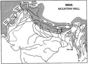
Question 4: What, has been the influence of the Northern Mountain Wall on the Indian Sub-continent?
Answer: (i) Since historic times, the movement of the people across the Himalayas has been limited. This helped in the development of a distinct culture of its own.
(ii) It prevents the cold winds coming from Central Asia to India.
(iii) Monsoon winds which scale the heights along the Himalayas cause rainfall in the Indian sub-continent.
(iv) The glaciers and snow fields of the Himalayas are the source of a large number of perennial rivers.
(v) Heavily forested slopes of the Himalayas provide valuable timber and other useful forest products.
(vi) The Himalayas give shelter to a wide variety of wild animal life. Thus, it maintains the balance in ecosystem.
Map of India : Give Reasons
Solutions for ICSE Class 10 Geography Chapter-2
Give Geographical Reasons for the following:
Question 1: Give reasons to justify that the Himalayas act as a ‘climatic divide’.
Answer: Himalayas are important for various reasons:
(i) It is the natural barrier.
(ii) Gives origin to great rivers of north India.
(iii) Is a source of timber and herbal products.
(iv) Acts as a barrier for the rain bearing winds of the Indian Ocean inducing them to give rain.
(v) It shuts off the cold winds of Central Asia.
Question 2: The Peninsular Plateau of India was a part of Gondwana Land hundreds of millions years ago.
Answer: The Peninsular Plateau of India was a part of Gondwanaland hundreds of millions years ago. The rocks that make up the Plateau match those of Africa not only in’the age and type, but also in the layer sequence in which they occur.
Question 3: The Peninsular rivers not navigable.
Answer: They are not suitable for navigation as they are shift flowing and non-perennial.
Question 4: The Peninsular Plateau of India is rich in mineral resources.
Answer: It is made up of very ancient, crystalline, hard, igneous and metamorphic rocks. Such rocks are rich in mineral resource.
Question 5: “Less land is available for agriculture on the west coast than on the east coast.” Why?
Answer: Western Ghats are high and steep and all along the western coasts there are numerous streams with small catchment areas. There are also a number of lagoons, backwaters and small lakes.
Question 6: Why does ‘The Narmada and Tapti do not form Deltas’.
Answer: They have a short mountain stage and flow on a rugged and rocky slope.
Question 7: Why is ‘The Delta region of the Indus is largely a waste land.’
Answer: It is usually flooded with brackish water. Brackish water is not suitable for agriculture or of any use.
Map of India : Differentiate
Solutions for ICSE Class 10 Geography Chapter-2
Question 1: Western Ghats and Eastern Ghats.
Answer:
| Western Ghats | Eastern Ghats |
| 1. They are higher. The highest peak in the Western Ghats is Anaimudi with a height of 2,695 m. | They are lower. The highest peak in the Eastern Ghats is Mahendragiri with a height of 1,500 m. |
| 2. They rise steeply from the west coast. | They rise gently from the east coast. |
| 3. The hills are continuous. | The hills are discontinuous. |
| 4. All the rivers of the Deccan Plateau rise in the Western Ghats. | The rivers cut valleys through the Eastern Ghats. |
Question 2: Delta and an estuary.
Answer:
| Delta | Estuary |
| 1. A delta is a triangular tract of sediments at the mouth of a river. | An estuary is a deep valley formed at the mouth of a river. |
| 2. A delta is formed due to gentle slope of land where river becomes sluggish and mud develops in its channels. | When slope of the land is prominent, water swiftly joins the Sea and there develops a deep valley or an estuary at the mouth of a river. |
Question 3: The Eastern Coastal Plain and Western Coastal Plain.
Answer:
| Eastern Coastal Plain | Western Coastal Plain |
| 1. It streches from the mouth of the river Ganga to Kanyakumari. | It stretches from Kutch to Kanyakumari. |
| 2. It lies between the Eastern Ghats and the Bay of Bengal. | It lies between the Western Ghats and the Arabian Sea. |
| 3. It is broader. | It is narrower. |
| 4. It is covered by the Deltas of the rivers Mahanadi, Godavari, Krishna and the Kaveri. | There are no deltas as the rivers flow fast down towards the Ghats. |
| 5. More land is available for agriculture. | Less land is available for agriculture. |
| 6. The deltas are not suitable for harbours as their mouths are always blocked by silt. | The coast is highly indented and hence dotted with many ports like Mumbai, Marmagoa and Cochin. |
| 7. It is known as the Northern Circars in the north of the delta of Godavari and the Coromandel Coast to the south of the delta. | West Coast is known as the Konkan coast in Maharashtra, the Kanara coast in Karnataka and the Malabar coast in Kerala. |
Question 4: Himalayan Rivers and Peninsular Rivers.
Answer:
| Himalayan Rivers | Peninsular Rivers |
| 1. These rivers originate from the snowclad mountains of the Himalayas. | The peninsular rivers originate from the Deccan Plateau. |
| 2. The catchment area of the Himalayan rivers is very extensive. | The catchment area of the peninsular rivers is very limited. |
| 3. The Himalayan rivers are perennial. | The peninsular rivers are Seasonal. |
| 4. Suitable for irrigation | Not suitable for irrigation |
| 5. These rivers flow through deep gorges and canyons, in the Himalayan regions. | These rivers flow in deep rift valleys due to resistant terrain. |
| 6. Flowing slowly on a long stretch of flat land, these rivers form meanders. Hence, they are not suited for generation of hydel-power. | These rivers flow with high speed and form waterfalls. They are suitable for generation of hydel-power. |
Map of India : Map Plotting
Solutions for ICSE Class 10 Geography Chapter-2
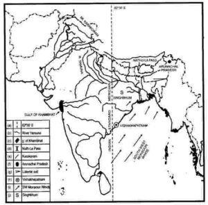
Question 1: On the outline map of India provided:
(a) Draw, name and number the Standard Meridian.
(b) Label the river Yamuna.
(c) Shade and name the Gulf of Khambhat.
(d) Mark and name the Nathu-La Pass.
(e) Mark and name the Karakoram Range.
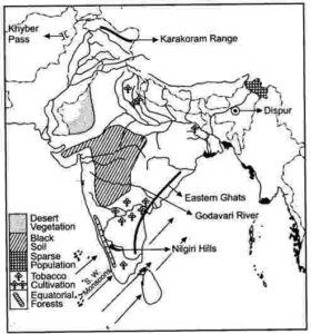
(f) Shade and name a sparsely populated State in Northeast India.
(g) Shade a region with laterite soil in Eastern India.
(h) Mark with a dot and name Vishakhapatnam.
(i) Mark and name the winds that bring rain to West Bengal in summer.
(j) Print S on the iron mines in Singhbhum.
(a) Mark and name Chennai
Answer:
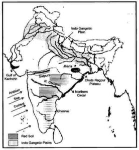
Question 2: On the outline map of India provided:
(a) Mark and name Chennai
(b) Label the river Godavari
(c) Shade and label the Chhota Nagpur Plateau
(d) Shade and name the Gulf of Kachchh
(e) Mark and name the Indo-Gangetic Plains
(f) Shade and label an area with Red Soil
(g) Mark and name the winds which bring rain to Mumbai in July and August
(h) Mark and name the Satpura Range
(i) Mark and name the Jharia Coal Field
(j) Shade and label the Northern Circar coastal region
Answer
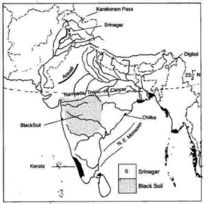
Question 3: On the outline map of India provided:
(a) Draw, name and number the Tropic of Cance
(b) Label the river Narmada
(c) Shade and name Lake Chilka
(d) Mark and name the Aravali Mountains
(e) Mark and name the Karakoram Pass
(f) Shade and name a densely populated state in South India
(g) Shade and name a region with black soil
(h) Mark with a dot and name Srinagar
(i) Mark and name the winds which bring rain in winter to the Coromandel Coast
(j) Name and print O on an oilfield in North-east India.
Answer:
Question 4: On the outline map of India provided:
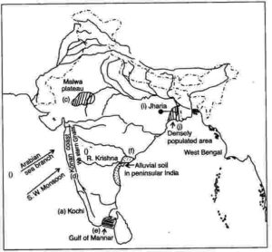
(a) Mark and name Kochi.
(b) Label the river Krishna.
(c) Shade and label the Malwa Plateau.
(d) Mark and label the Konkan Coast.
(e) Shade and label the Gulf of Mannar.
(f) Shade and label an alluvial soil area in Peninsular India.
(g) Mark with arrows the direction of the Arabian Sea branch of South West Monsoon Winds.
(h) Shade and label the Western Ghats.
(i) Mark the Jharia coal field.
(j) Shade and name a densely populated area.
Answer:
Question 5: On the outline map provided
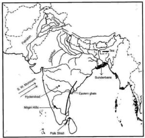
(a) Label the river Chenab.
(b) Label the river Chambal.
(c) Shade and label the Nilgiri Hills.
(d) Mark and label the Eastern Ghats.
(e) Mark and name the port city of Pakistan.
(f) Mark and label Hyderabad.
(g) Shade and label the Sunderbans.
(h) Mark and name the Palk Strait.
(i) Mark and label a region North of the Tropic of Cancer where tea is grown extensively.
(j) Mark and name the winds which bring rain to Mumbai in July and August.
Answer:
Question 6: On the outline map provided:
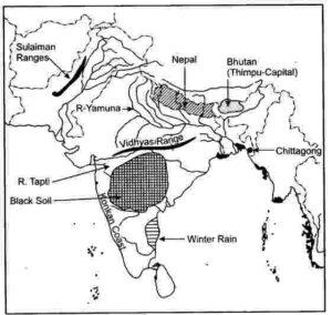
(a) Shade and label the country Nepal.
(b) Shade and label an area of black soil in India.
(c) Mark and label the Konkan Coast.
(d) Shade and label one region of winter rainfall in India.
(e) Sade and label the Sulaiman Ranges.
(f) Label the River Yamuna.
(g) Label the River Tapti.
(h) Shade and label the Vindhya Ranges
Answer
Question 7: Show the following on the outline map provided:
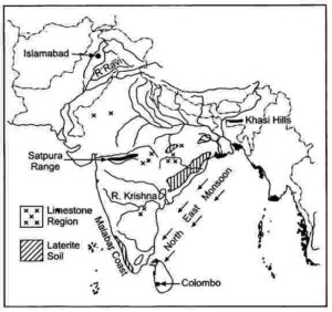
(a) Shade and label the Satpura Range.
(b) Label the River Krishna.
(c) Label the River Ravi.
(d) Shade and label the Khasi Hills.
(e) Mark with arrows the direction of the North-East Monsoon winds over the Bay of Bengal.
(f) Mark and label the Malabar coast.
(g) Shade and label an area of Laterite soil in India.
(h) Shade and label an area of Limestone in India.
Answer:
Question 8: On the outline map of the Indian sub-continent provided to you at the end of this question paper:
(i) Mark with a bold line and label:
(a) The Karakoram Range.
(b) The Eastern Ghats.
(c) The Nilgiris
(ii) Shade and name one region for the : Black soil.
(iii) Mark and label:
(a) The Khyber Pass
(b) The capital city of Assam.
(c) River Godavari.
(iv) (a) Identify, shade and name:
(1) A region of sparse population (less than 50 pp sq.) in North-Eastern India.
(2) A region of ‘Equatorial Forests’.
(b) Mark with one long arrow, the direction of the Summer Monsoon over the Bay of Bengal.
Answer
Question 9: On the map of India.
(a) Mark and name the Himalaya Mountains.
(b) Mark and name the Passes : Bolan, Gomal, Shipkila (Shipki).
Answer:
Question 10: On the map of India,
(a) Label the Konkan Coast, Malabar Coast and the Coromandel Coast in their proper places.
(b) Shade and name the Rann of Kutch.
(c) Mark and name the Ajanta Range.
(d) Mark and name the Khasi-Jaintia Hills.
(e) Mark and name the Patkoi Hills.
(f) Mark and name the Naga Hills.
(g) Mark and name the Cardamom Hills.
(h) Mark and name the Annamalai Hills. Name its highest peak, Anaimudi.
Answer:
Question 11: On the map of India,
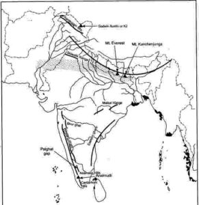
(a) Mark and name the Shiwalik Range.
(b) Mark and name, the Western Ghats with two gaps, Bhor Ghat and Palghat Gap.
(c) Mark and name the peak on the Karakoram Mts, (Mt. Godwin Austien or Mt. K2).
(d) Mark and name, the highest peak on the Himalayas, (Mt Everest).
(e) Mark and name Mt. Kanchenjunga.
(f) Mark and name the Maikal Range.
(g) Shade and name the Indo-Gangetic Plain.
Answer:
Question 12: One the map of India:
(a) Label the rivers: Mahanadi, Kaveri, Chambal, Betwa.
(b) Show by an arrow and name the Gulfs: Khambat, Kutch, Mannar
(c) Name the Lakes: Chilka and Pulicat.
(d) Write in bold letters Bay of Bengal, Arabian Sea, Indian Ocean in their appropriate places.
Answer:
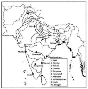
Question 13: On the map of India, mark with a dot and name the cities,
(a) The National Capital (Delhi).
(b) The Capital of Maharashtra Or the Commercial Capital of India (Mumbai).
(c) The Capital of West Bengal (Kolkata).
(d) The Capital of Tamil Nadu (Chennai).
(e) The Capital of Karnataka (Bangalore).
(f) The Capital of Andhra Pradesh (Hyderabad).
(g) The city whose Local Time is taken as the Standard Time of India (Allahabad).
(h) Vishakhapatnam.
(i) Kochi.
(j) Capital of Jammu-Kashmir (Srinagar).
Answer:
Map of India : Name the Following
Solutions for ICSE Class 10 Geography Chapter-2
Question 1:
(i) Which is the biggest country of South Asia with regard to area?
(ii) Name the largest country with regards to its population.
Answer:
(i) India, (ii) India.
Question 2: Name the physical divisions into which India can be divided.
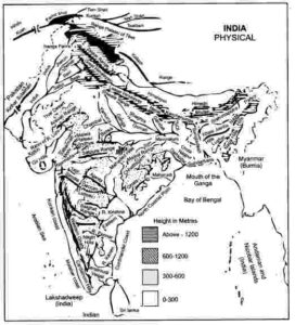
Answer: India can be divided into five main physical divisions such as, Mountainous region of the north, Indo-Gangetic plain, Southern Plateau region, Coastal plains and Thar desert.
Question 3: Name the ranges in the western branch of the Himalayas.
Answer: The western branch of the Himalayas contain Sulaiman, Kirthar and Central Makaran ranges.
Question 4: Name the five most important peaks of the Himalayan Range.
Answer:
(i) Mount Everest (6,000 metres)
(ii) Godwin Austin (8,611 metres)
(iii) Kanchenjunga (8,598 metres)
(iv) Makalu (8,481 metres)
(v) Dholagiri (8,172 metres).
Question 5: Mention the important passes in the western branch of the Himalayas.
Answer: The important passes in the western branch of the Himalayas are Khyber Pass, Gomal Pass, Bolan Pass and Tochi Pass.
Question 6: ‘India is bounded on three sides by the Sea’. Name them.
Answer: India is bounded by the Arabian Sea in the west, the Bay of Bengal in the east and in the south the Palk Strait separates India from Sri Lanka.
Question 7: Name the main rivers of South-Asia flowing into the Indian Ocean.
Answer: The main rivers flowing into the Indian Ocean are Ganga, Brahmaputra, Indus and Irrawady.
Question 8: Name the two river systems of India.
Answer: The two river systems of India are: The rivers of Northern Plain and the rivers of Peninsular India.
Question 9: By what name is Brahmaputra known in:
(i) Tibet. (ii) Bangladesh.
Answer: (i) Tsang-Po. (ii) Jamuna.
Question 10: Name the important ports of the western coastal strip.
Answer: The most important ports of the western coastal strip are Mumbai and Kochi.
Question 11: Name the two important inlets in the Gujarat region of the west coast strip?
Answer: The two important inlets in the Gujarat region of the west coast strip are: the Gulf of Kachchh and the Gulf of Cambay.
Question 12: Name the important harbours of Coromandel Coast.
Answer: Vishakhapatnam, Paradeep, Chennai and Tuticorin.
– : End of Map of India ICSE Geography Solutions :-
-: also visit :-
- Subjective / Descriptive Type Questions (Sec-B) of Sem-2 for ICSE Class-10
- Sem-2 Specimen / Model / Sample Paper for ICSE Class-10
- ICSE Class-10 Text book Solutions, Notes , Syllabus, Paper, Notes
- ICSE Board Paper Class-10 Solved Previous Year Question
Thanks
Please share if it is helpful
2 thoughts on “Map of India Solutions for ICSE Class 10 Geography Ch- 2”
Sir pls agriculture wale chapter ke bhi dedena notes ch 8
uploaded